
Técnica GEOBIA e as mudanças na paisagem de áreas naturais protegidas
Resumo
R E S U M O
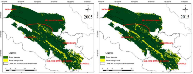
A degradação em áreas naturais protegidas por Lei tem aumentado nos últimos anos. Logo, é necessário desenvolver estratégias para monitorar o espaço e gerar subsídios à fiscalização em tempo hábil. Mapeamentos sistemáticos anuais podem cumprir essa missão, porém, em regiões cujo uso da terra é heterogêneo, fitofisionomias de vegetação natural não-florestal são, comumente, confundidas com áreas antropizadas para pasto, especialmente no bioma Cerrado. Assim, o objetivo do presente estudo foi apresentar a técnica GEOBIA para avaliação da dinâmica temporal do uso e cobertura da terra no Parque Nacional da Serra da Canastra (PNSC), localizado no Estado de Minas Gerais, entre os anos de 2005 e 2015. Para tanto, foram ponderadas a informação espectral de cada pixel, as informações referentes aos indicadores fenológicos, e as informações de forma, textura e contexto de objetos segmentados. Os resultados apontaram o aumento de 2.606,82 ha (1,32%) da área antropizada no PNSC, o que torna necessário aumentar medidas mitigatórias na região e intensificar fiscalizações. Diferente de mapeamentos sistemáticos, o método proposto é capaz de subsidiar a tomada de decisões em Unidades de Conservação heterogêneas.
Palavras-chave: Dinâmica temporal, Monitoramento de mudanças na cobertura da terra, Planejamento territorial, Unidades de Conservação.
GEOBIA technique and changes in the landscape of protected natural areas: a case study in the Serra da Canastra National Park (Brazil)
A B S T R A C T
Degradation in natural areas protected by Law has increased in recent years. Therefore, it is necessary to develop strategies to monitor the space and generate subsidies for prompt inspection. Annual systematic mapping can fulfill this mission, however, in regions whose land use is heterogeneous, phytophysiognomies of natural non-forest vegetation are commonly confused with anthropized areas for pasture, especially in the Cerrado biome. Thus, the objective of the present study was to present the GEOBIA technique for assessing the temporal dynamics of land use and cover in the Serra da Canastra National Park (PNSC), located in the state of Minas Gerais, between 2005 and 2015. For so much, the spectral information of each pixel, the information referring to the phenological indicators, and the form, texture, and context information of segmented objects were weighted. The results showed an increase of 2,606.82 ha (1.32%) of the anthropized area in the PNSC, which makes it necessary to increase mitigation measures in the region and intensify inspections. Unlike systematic mappings, the proposed method can support decision-making in heterogeneous Conservation Units.
Keywords: Temporal dynamics, Land cover changes monitoring, Territorial planning, Conservation Units