
Descritores dinâmicos espectrais e Classificação por abordagem híbrida para estudos de Detecção de Mudanças
Resumo
R E S U M O
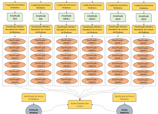
As paisagens como conhecemos e vemos estão em constante mudança devido a processos naturais e antrópicos de diferentes magnitudes espaciais e temporais. Para entendermos essas mudanças, elas necessariamente devem ser observáveis ou mensuráveis. Atualmente se coloca o Sensoriamento Remoto como uma das mais modernas formas de monitoramento da paisagem devido a métodos aplicáveis aos seus produtos que permitem análises qualitativas e quantitativas das alterações na paisagem, ocasionadas pelos complexos padrões de uso e ocupação da terra ao longo do tempo. Dentre os muitos métodos de detecção de mudanças há o de detecções automáticas a partir de algoritmos, que simplificam os processamentos e capturam as transformações de forma rápida e sistemática. Assim, o objetivo desse trabalho é entender como se comporta os algoritmos de detecção de mudanças em uma classificação híbrida integrada. Essa classificação será testada usando imagens de mesoresolução como as dos satélites LANDSAT num contexto temporal de 35 anos em 8 datas e espacial que encobre todo o estado do Rio de Janeiro e suas complexidades de cobertura. O trabalho está construído pensando em resolver os problemas metodológicos da construção desses algoritmos, na classificação das mudanças e na exploração desses algoritmos para entender suas vantagens e limitações. Ao fim tem-se que para o estado do rio de Janeiro os descritores do NDBI, SWIR 1 e SWIR 2 são o que melhor nos atendem para a identificação rápida de mudanças de diferentes tipologias na área, onde o melhor estatisticamente e visualmente foi o NDBI.
Palavras-Chaves: Mudanças da Paisagem, Descritores Espectrais, Algoritmos de Mudança, Sensoriamento Remoto.
Dynamic spectral descriptors and Classification by hybrid approach for Change Detection studies
A B S T R A C T
The landscapes as we know and see them are constantly changing due to natural and anthropic processes of different spatial and temporal magnitudes. To understand these changes, they must necessarily be observable or measurable. Currently Remote Sensing is considered one of the most modern ways of monitoring the landscape due to methods applicable to its products that allow qualitative and quantitative analysis of changes in the landscape, caused by the complex patterns of land use and occupation over time. Among the many methods of detecting changes, there is automatic detection using algorithms, which simplify processing and capture transformations quickly and systematically. Thus, the objective of this work is to understand how the change detection algorithms behave in an integrated hybrid classification. This classification will be tested using mesoresolution images such as those of the LANDSAT satellites in a 35-year temporal context over 8 dates and a spatial one that covers the entire state of Rio de Janeiro and its coverage complexities. The work is built thinking about solving the methodological problems of the construction of these algorithms, in the classification of changes and in the exploration of these algorithms to understand their advantages and limitations. In the end we have that for the state of Rio de Janeiro the descriptors of NDBI, SWIR 1 and SWIR 2 are the ones that best serve us for the quick identification of changes of different types in the area, where the best statistically and visually was the NDBI.
Keywords: Landscape Changes, Spectral Descriptors, Landscape Change Algorithms, Remote Sensing.