
Áreas verdes na Zona Oeste do Rio de Janeiro: patrimônio ambiental de Mata Atlântica | Green areas in the West Zone of Rio de Janeiro: the environmental heritage of Atlantic Forest
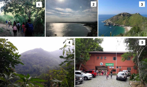
Este artigo reúne informações, características, fotos e dados de pesquisas científicas sobre as áreas verdes do patrimônio ambiental da Zona Oeste. A cidade do Rio de Janeiro é dividida em Áreas de Planejamento (AP). A AP-5 (Zona Oeste) é a região com maior concen-tração populacional do Estado do Rio de Janeiro, com cerca de 50% de cobertura vegetal de bioma Mata Atlântica, com ecossistemas de floresta, restinga e manguezal; apresenta notável beleza cênica em um conjunto de fatores como maciços, praias, cachoeiras e rios. A Zona Oeste foi cenário para eventos históricos pré-coloniais, coloniais até a urbanização e industrialização que ocasionou alteração das áreas verdes. As áreas protegidas por lei ambiental na AP-5 são o Parque Estadual da Pedra Branca (PEPB), o Parque Estadual do Mendanha/Gericinó e Parque Natural Municipal do Mendanha, e áreas de restingas e manguezais que circundam a Baía de Sepetiba e Marambaia, dentro da Reserva Biológica de Guaratiba (REBIO) e a RPPN (Reserva Particular do Patrimônio Natural) Ana Gonzaga, além de áreas sobrepostas as citadas. A Floresta de Camboatá, em Deodoro, também foi considerada nesta exposição. O objetivo deste trabalho foi fazer um levantamento e sintetizar as informações sobre as áreas verdes da Zona Oeste a partir de dados bibliográficos e vivência in loco, além de ilustrar com fotos as paisagens naturais. A proposta contribuiu para divulgação das áreas verdes da Zona Oeste, fomentando a importância de conservação ambiental.
Palavras-Chaves: Mata Atlântica, Pedra Branca, Mendanha, Camboatá, Unidade de Conservação, Zona Oeste.
Green areas in the West Zone of Rio de Janeiro: environmental heritage of the Atlantic Fo-rest
A B S T R A C T
This article gathers information, characteristics, photos and data from scientific research on the green areas of the environmental heritage of the West Zone. The city of Rio de Janeiro is divided into Planning Areas (AP). AP-5 (West Zone) is the region with the highest population concentration in the State of Rio de Janeiro, containing about 50% of vegetation cover of the Atlantic Forest biome, with forest, sandbank and mangrove ecosystems; presents remarkable scenic beauty in a set of factors such as massifs, beaches, waterfalls and rivers. West Zone was a backdrop for pre-colonial historical events, from colonial to urbanization and industrialization that caused changes in green areas. The areas protected by environmental law in AP-5 are the Pedra Branca State Park (Parque Estadual da Pedra Branca – PEPB), the Gericinó-Mendanha State Park (Parque Estadual Gericinó-Mendanha) and the Mendanha Municipal Natural Park (Parque Natural Municipal do Mendanha – PNM), and areas of sandbanks and mangroves that surround Sepetiba Bay and Marambaia, within the Guara-tiba Biological Reserve (Reserva Biológica de Guaratiba – REBIO) and the Private Reserve of Natural Heritage Ana Gonzaga (Reserva Particular do Patrimônio Natural Ana Gonzaga), in addition to the areas mentioned above. The Camboatá Forest, in Deodoro, was also considered in this exhibition. The objective of this work was to make a survey and synthesize the information about the green areas of the West Zone from bibliographic data and on-site experience, in addition to illustrating the natural landscapes with photos. The proposal contributed to the divulgation of green areas in the West Zone, promoting the importance of environmental conservation